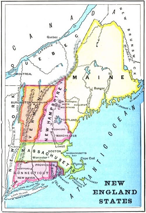
QUESTIONS - Examine the map and answer the questions. Map of New England
How many New England States are there?
Which two states are north of Massachusetts?
Which two states are south of Massachusetts?
Which state is west of Massachusetts?
Which large river flows between Vermont and New Hampshire?
Through which states does the Connecticut River flow?
Which rivers flow through Maine?
Which river flows through New Hampshire?
Which of the New England states touch the Atlantic Ocean?
Which of the New England states touch New York?
Which lake is between Vermont and New York?
Which country is north of New England?
Which country is east of Maine?
Which large island is south of Connecticut?
Which body of water is between Connecticut and Long Island?
Name the New England states.
Which of the New England states is the largest?
Which of the New England states is the smallest?
Where are the Green Mountains?
Where are the White Mountains?
Which large river flows into Long Island Sound?
Which cape is located in the eastern part of Massachusetts?
Which three rivers flow into the Atlantic Ocean?
ANSWERS
There are six New England States.
New Hampshire and Vermont are north of Massachusetts.
Connecticut and Rhode Island are south of Massachusetts.
New York is west of Massachusetts.
The Connecticut River flows between Vermont and New Hampshire.
The Connecticut River flows through Massachusetts and New Hampshire.
The Kennebec River and Penobscot River flow through Maine.
The Merrimack River flows through New Hampshire.
Maine, New Hampshire, Massachusetts, Rhode Island, and Connecticut touch the Atlantic Ocean.
Vermont, Massachusetts, and Connecticut touch New York.
Lake Champlain is between Vermont and New York.
Canada is north of New England.
Canada is east of Maine.
Long Island is south of Connecticut.
Long Island Sound is between Connecticut and Long Island.
Maine, New Hampshire, Vermont, Massachusetts, Rhode Island, and Connecticut are the New England states.
Maine is the largest New England state.
Rhode Island is the smallest New England state.
The Green Mountains are in Vermont.
The White Mountains are in New Hampshire.
The Connecticut River flows into Long Island Sound.
Cape Cod is located in the eastern part of Massachusetts.
The Penobscot River, Kennebec River, and Merrimack River all flow into the Atlantic Ocean.
Notebook Work: Label the following on the map of New England: Canada, the Atlantic Ocean, Maine, New Hampshire, Vermont, Massachusetts, Rhode Island, and Connecticut.
 First Lessons in World Geography
World Geography
First Lessons in World Geography
World Geography


 About
About Curriculum
 Navigation